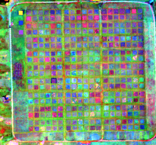
A remotely sensed spectral image of the Cedar Creek Ecosystem Science Reserve prairie grassland biodiversity experiment (BioDIV). Variation in plot functional diversity and ecosystem properties can be remotely detected.
Three years ago, CBS ecologist Jeannine Cavender-Bares and colleagues set out to make answering that question easier by exploring how patterns of light reflected skyward and captured by devices on planes could be used to surmise characteristics of plants.
Cavender-Bares and colleagues from the University of Minnesota and several other institutions began by setting up study plots of varying tree diversity. They then gathered hyperspectral data by plane at those sites as well as at the well-known prairie grassland diversity experiment at Cedar Creek Ecosystem Science Reserve and compared the aerial data with on-the-ground measurements of plant traits. So far they have found strong relationships between spectral diversity — the range of light bounce-back patterns — and species richness. They’ve also found a correlation between the spectral data and functional diversity — traits such as how thick leaves are or the ability to tolerate drought and heat — proving that eye-in-the-sky observations can indeed help us assess and track changes in plant traits and shed valuable light on how vegetation is likely to respond to future changes.
Even as results roll in, the team is now setting its sights even higher, participating in a lofty proposal to launch a satellite that can do the job on a global scale. Known as the Global Biodiversity Observatory, the initiative would use statistical tools, like those developed through the Cedar Creek Study, to provide similar information to that gained by airplane fly-overs but covering far more — and far more remote — territory, yielding larger-scale conclusions and opening the door to conserving far more ecosystems.
“With the help of integrative analyses and scaling approaches we are developing at Cedar Creek, satellites with advanced hyperspectral imaging capability would allow scientists to look at changes in functional diversity through time and in response to environmental change in some of the most diverse and most remote regions on the planet,” Cavender-Bares says. — Mary Hoff
RELATED: Planetary Perspective on Biodiversity